
The Toronto Belt Line Railway

Many people in Toronto today recognize the name Belt Line Trail as a route for walkers, runners and cyclists, but this path is actually the remains of a more ambitious idea that was brought to life, albeit briefly, more than a century ago.
Building a Railway to Build Suburbs
In 1889, a group of businessmen created the Toronto Belt Land Corporation with the intention of developing large areas of land north and west of Toronto’s existing downtown core. At the time, these properties were beyond the reach of the city’s streetcar network.
If these new neighbourhoods were going to attract residents, transportation would be necessary.
The solution was a steam railway that would connect the developing suburbs with downtown Toronto.
The project eventually took the form of two separate loops. The larger northern route travelled through the Don Valley and areas such as Moore Park, Forest Hill and Fairbank, while the western route extended toward Swansea and the Humber Valley.
Construction began in 1890, but the project quickly ran into financial difficulties. The real estate boom that had encouraged the development began to decline, and the Belt Line company went bankrupt before construction was complete.
The Grand Trunk Railway eventually finished the line, and passenger service began on July 30, 1892.
A Railway Through Forest Hill
One of the historic surveys in our collection provides an interesting look at the Belt Line during this period.

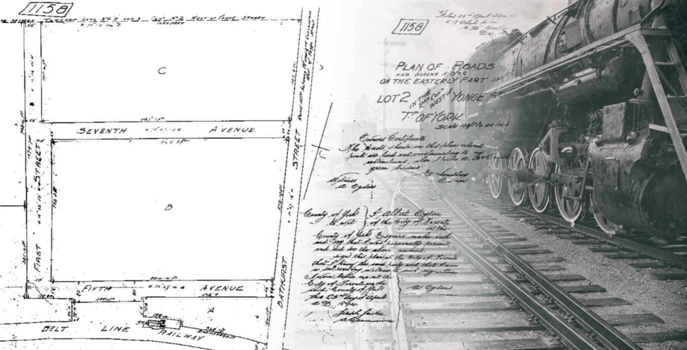
Historic survey plan showing the Belt Line Railway, station, Bathurst Street, First Street, Fifth Avenue and Seventh Avenue in 1894.
Registered Plan 1158, filed in 1894, shows part of the former Township of York near Bathurst Street. Along the southern portion of the plan is the Belt Line Railway, with a small structure beside the tracks identified simply as “Station.”
The surrounding street names also look very different from what we know today.
The plan shows First Street, Fifth Avenue and Seventh Avenue. Comparing their locations with the todays streets it appears that Fifth Avenue corresponds with present-day Elm Ridge Drive, Seventh Avenue with Ridelle Avenue, and First Street with the general alignment of Lawnhurst Boulevard.
Bathurst Street, however, is still in the same recognizable location.
Once these modern street names are identified, the 1894 plan becomes much easier to place within the city.
The date of the survey is also important. Passenger service on the Belt Line ended in November 1894, meaning this plan was prepared during the final year that passenger trains were operating along the route.
It gives us a snapshot of the area while the railway, station and surrounding subdivision were all still part of the same developing landscape.
A Short-Lived Passenger Railway
At first, the Belt Line attracted attention from people looking to escape the city for a Sunday excursion into the surrounding countryside.
The railway was also useful to real estate agents and investors, who could use the line to visit lands being promoted for future development.
The idea was simple enough: better transportation would make the new suburban lands more attractive, while the people moving into those new neighbourhoods would provide passengers for the railway.
Unfortunately, the expected growth did not happen quickly enough.
The economic depression of the 1890s slowed the real estate market, and the Belt Line struggled to attract enough regular commuters. By July 1894, service had already been reduced.
On November 17, 1894, passenger operations came to an end after only 27 months of operations.
The Railway After Passenger Service
The end of passenger service did not mean that the railway corridor immediately disappeared.
A second survey in our collection, dated 1913, shows another section of the former route near Moore Avenue and Heath Street East.
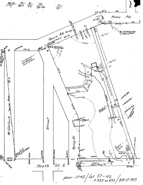
1913 survey showing the railway track, Moore Avenue Bridge, Heath Street East and the surrounding ravine landscape.
Unlike the 1894 Forest Hill plan, this survey shows a much more irregular landscape. Roads, bridges, a ravine and railway infrastructure all occupy the same area.
The survey also refers to a “track” running through the property.
Based on its location, this appears to follow the former Belt Line corridor, although the survey itself does not clearly label it as the Toronto Belt Line Railway.
This fits with the later history of the route. Portions of the northern Belt Line were brought back into use for freight service after passenger operations had ended.
By this time, the railway was serving a different purpose. Instead of carrying commuters into newly planned suburbs, portions of the line were being used to transport fuel and building materials into neighbourhoods that were finally beginning to grow.
The Neighbourhoods Arrived After the Trains Left
A later, undated survey provides another look at the railway corridor after the surrounding area had developed considerably.
The plan identifies the area as the Township of East York, which would mean this plan was created around 1924 or later. The survey shows the Belt Line Railway running through a much more developed landscape, surrounded by established streets and registered subdivisions.
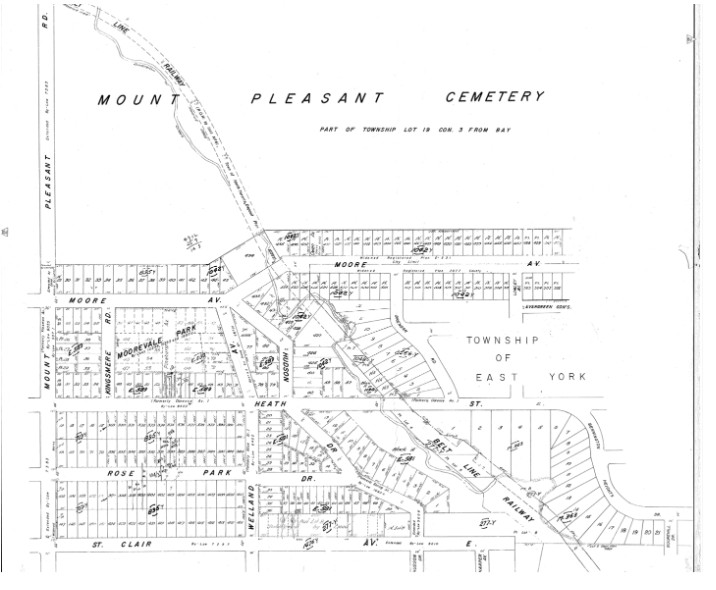
This plan clearly labels the Belt Line Railway as it passes through the area between Mount Pleasant Cemetery, Moore Avenue, Heath Street East and St. Clair Avenue East.
The difference between this plan and the 1894 Forest Hill survey is striking.
The earlier plan contains large blocks of land and a relatively simple street layout. The later plan is filled with registered lots, established streets and subdivisions surrounding the railway corridor.
In a way, this shows one of the more interesting parts of the Belt Line story.
The railway had been created partly to encourage suburban growth, but passenger service disappeared before much of that growth took place.
Eventually, as Toronto expanded, the old railway corridor became surrounded by the city that its original promoters had hoped would develop around it.
From Railway to Beltline Trail
Railway use continued along portions of the route for decades, but eventually those operations also came to an end. Sections of the former railway lands were later acquired by the City of Toronto and converted into recreational space.
Today, much of the former route survives as the Beltline Trail. The original stations are gone, although several former station locations have since been commemorated by the City.
What began as a plan to connect new suburban communities with downtown Toronto ultimately became something very different.
The passenger railway lasted only a little more than two years, but the line itself survived through freight use, neighbourhood development and eventually its conversion into public space.
The historic surveys help show that transition. In 1894, we see the Belt Line beside a station and an early subdivision in Forest Hill. By 1913, the railway corridor is still visible after passenger service had ended. In the later plan, the Belt Line remains while established streets, lots and neighbourhoods have grown around it.
More than a century later, the trains are gone, but the route can still be followed through Toronto and historic survey plans help explain how it got there.
References:
Toronto Railway Historical Association — Toronto Belt Line
Historical overview of the Toronto Belt Line Railway, including its formation, routes, operation, decline and later freight use.
https://www.trha.ca/history/railways/toronto-belt-line/
City of Toronto — Beltline Trail Commemorative Stations
Information on the former Belt Line corridor, station locations and the modern Beltline Trail.
https://www.toronto.ca/city-government/planning-development/construction-new-facilities/park-facility-projects/beltline-trail-commemorative-stations/
Spacing Toronto — “Throwback Thursday: The Belt Line Railway”
Background on the railway’s connection to suburban development, ridership and its place in Toronto’s transportation history.
https://spacing.ca/toronto/2009/07/16/throwback-thursday-the-belt-line-railway/
Protect Your Boundaries — Historic Survey Archive
Historic survey plans used in this article, including the 1894 Forest Hill plan, the 1913 Moore Avenue and Heath Street survey, and the later plan showing the Belt Line Railway through the Mount Pleasant and Moore Park area. Survey plans from the Protect Your Boundaries archive.









Protect Your Boundaries Inc. is a licensed member of the Association of Ontario Land Surveyors, and is entitled to provide cadastral surveying services to the public of the Province of Ontario in accordance with the provisions of the Surveyors Act R.S.O. 1990, Chapter S29.