Lambton’s Past Through Old Survey Maps


There’s something fascinating about uncovering an old land survey plan, it’s like holding a time machine on paper, showing exactly how a place once looked and how it has changed over time. Recently, I looked at some 19th and early 20th-century survey maps of Lambton (in Toronto), and they tell an interesting story about how this little mill village changed over time. These maps aren’t fancy or colourful, but if you look closely, you can spot landmarks like mills, the Lambton House tavern, the Humber River and even a train station that once existed. Let’s take a casual stroll through Lambton’s past using these old maps and see what we can learn about how the area grew, what is still there and what disappeared, and why these century-old survey maps matter.
Lambton in 1888: A Mill Village by the River
In an 1888 survey map of Lambton, you will notice Dundas St. running diagonally and the Humber River’s edge on the left. A “Road allowance closed by By-Law” is marked at the top; a clue that an old, planned road by the river was shut down, likely because the river’s course or conditions made it impractical.
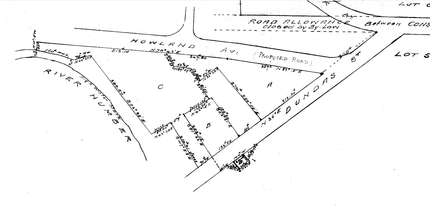
In 1888, Lambton was still very much a mill town. Old maps show property lots clustered around Dundas Street and the Humber River. The fact that a road allowance had to be closed by a by-law suggests the river or terrain had shifted. Lambton’s main businesses were the water-powered mills along the river, and you can imagine the steady activity around them back then. Of course, there was also the Lambton House, a local tavern and hotel. Its building footprint appears on the map near Dundas Street, anchoring the east side of the river crossing. This 1888 map captures Lambton as a small riverside community built around its mills and the crossing on Dundas.
Lambton in 1902: Trains and Changing Times
This 1902 survey map covers the same area as the earlier plan but from a wider, zoomed-out view, showing more of the surrounding village. Here, Dundas Street runs through the center, and we see “Station Grounds” labelled at the top, indicating a railway station near Lambton. The map even marks “Lambton Station” and the building labelled “Hotel” along Dundas. A small rectangle by the river labelled “Mill” shows where a mill stood.
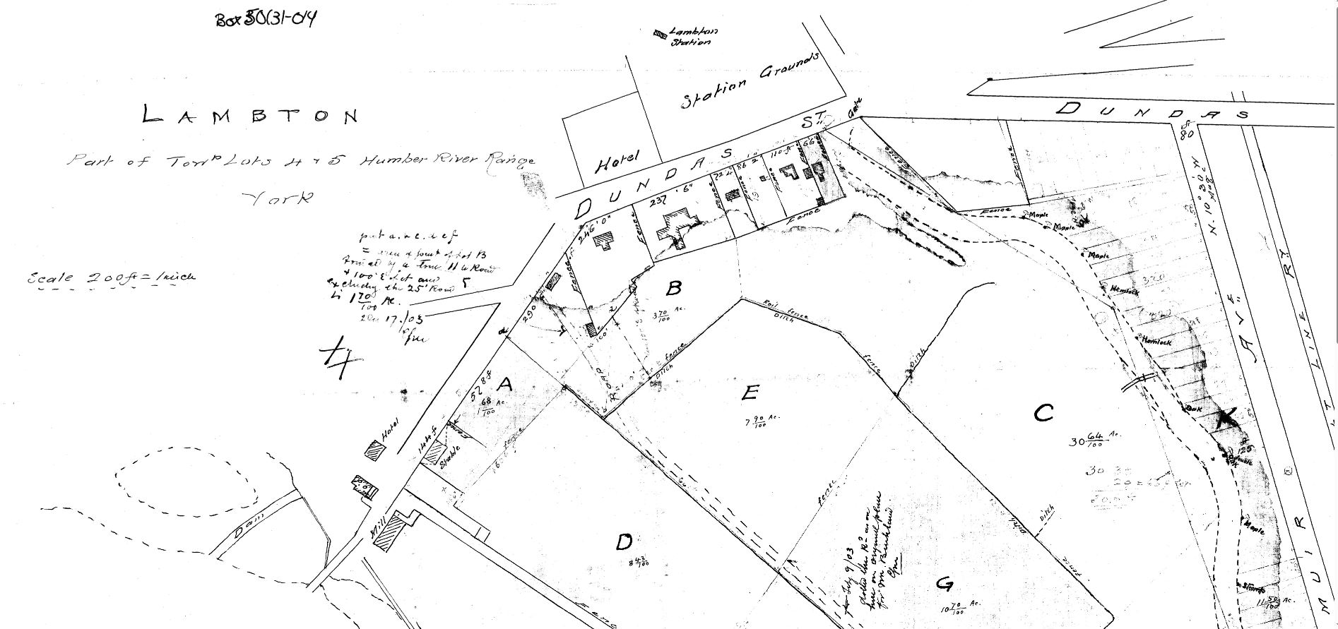
By 1902, we can see signs of new developments and the beginning of change. One big addition is the railway presence. This survey labels an area as “Station Grounds,” and even pins the name “Lambton Station”. In 1875, a railway line was built through the area, and for a time, passengers could catch a train at Lambton. The station isn’t around today, but the map preserves its memory. Additionally, on the 1902 map, two hotels appear: a prominent one beside the railway station and a smaller one to the west, near the river. The latter, marked “Hotel” near the Dundas crossing, is Lambton House, which ultimately closed its doors in 1888, likely a casualty of the larger, more modern establishment down the road. Mirroring this trend, the mills that gave Lambton its identity were on their last legs. The big water-powered flour mill had been converted to steam in the 1880s to cope with the Humber’s unpredictable water levels, but by the early 1900s, it had closed. The 1902 map still notes a “Mill” structure by the riverbank, but this was essentially the last of the old mills; it would burn down in a 1915 fire, not too long after this map was made. You also might notice the Humber River’s path on the map; its meandering course defines the property lines. Compared to today, the river’s alignment is a bit different in spots. The maps don’t show a dramatic river relocation (that would come later with flood controls), but you get the sense of a wide floodplain; surveyors even marked where fences and ditches were, skirting around swampy patches. All in all, the 1902 survey shows Lambton at a transitional moment: the railway era briefly intersecting with the mill era, and the reliable Lambton House, a centre piece to it all.
Lambton in 1929: Ruins and Remnants
A 1929 plan of the Lambton area (east side of the Humber). By this time, the mills are gone, and the plan labels the “ruins of old mill” on the right side. You can also see Fishers Road (an old name for part of the roadway) and notes about the new Government Road (the re-routed Dundas Street) at top.
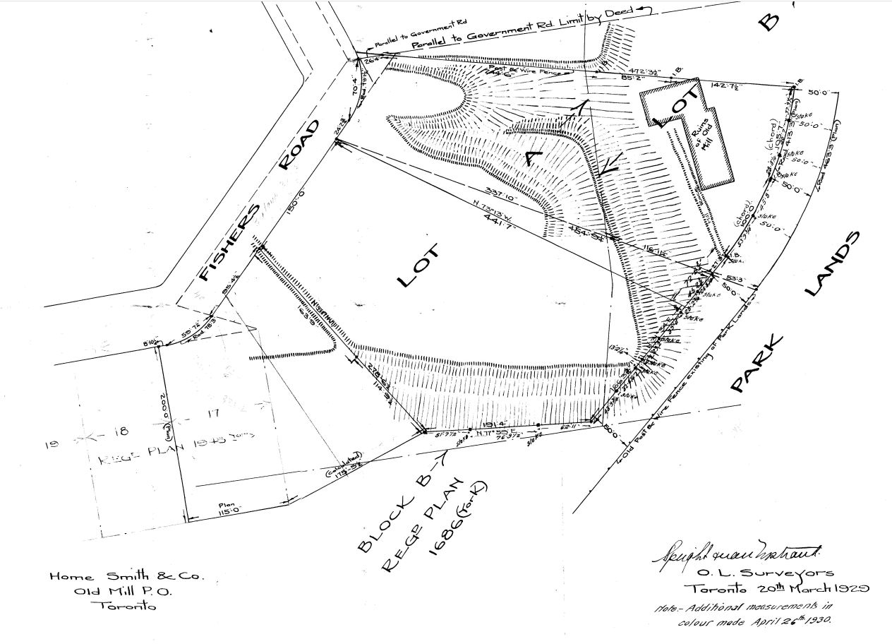
Fast-forward to 1929, and the maps show a very different picture for Lambton. The mills that once drove the local economy have vanished; hence, the surveyors note the “ruins of old mill” on the plan. This area by the river, which was likely once a quiet rural mill, was developed for residential use and the area by the river stood as parklands. Another big change was the road alignment: in 1928, Dundas Street was rerouted to a new high-level bridge just north of the old one. This meant the section of Dundas by Lambton House became a side road. Today, this id fittingly called Old Dundas Street. The 1929 map shows the transition of Lambton from a mill village to a residential area with a historic tavern by a now-tamed river.
Why These Old Maps Matter
Looking at these old survey maps, we get to time-travel and see Lambton’s story unfold. We see a village that started around mills and a river crossing, then adapted to railroads, and eventually faded into a suburban neighbourhood, leaving only a few hints of what was there before. History buffs and locals alike can appreciate how much change can happen in one spot: the mills are gone, the train station is gone, even the main road has moved, but Lambton House, which still hosts events and private gatherings, is still here as a tangible link to that past. These maps matter because they capture details that no longer exist on the ground. Instead of just reading about Lambton Mills in a book, the maps let us visualize it, where the mills stood, how the river curved, where the “Station Grounds” were, and how the old community was laid out. We can picture it as it once was, in all its bustling, gritty, mill-town glory, and understand how it became the place it is today.
References
1. City of Toronto. Discovery Walk: Lambton House Hotel and the Lower Humber River. 2017, toronto.ca, https://www.toronto.ca/wp-content/uploads/2017/11/97b9-Discovery-Walk-Lambton-House-Hotel-Lower-Humber-River.pdf.
2. “Lambton House.” Lambton House Official Site, Heritage York, https://lambtonhouse.org.
3. “History of Lambton House.” Lambton House Official Site, https://www.lambtonhouse.org/History.htm.
4. “Lambton House – A 19th Century Landmark.” Lambton House (lh2005_002.htm), https://lambtonhouse.org/lh2005_002.htm.
5. “Lambton Mills.” Etobicoke Historical Society, https://www.etobicokehistorical.com/lambton-mills.html.
6. Hiking the GTA. “Lambton Mills – Ghost Towns of the GTA.” Hiking the GTA, 29 August 2020, https://hikingthegta.com/2020/08/29/lambton-mills-ghost-towns-of-the-gta/.
7. “Lambton Mills.” Wikipedia, Wikimedia Foundation, 13 October 2024, https://en.wikipedia.org/wiki/Lambton_Mills.
8. “Lambton Station, Canadian Pacific Railway.” Toronto Railway Historical Association, TRHA, https://www.trha.ca/trha/history/stations/lambton-station-canadian-pacific-railway/.


Protect Your Boundaries Inc. is a licensed member of the Association of Ontario Land Surveyors, and is entitled to provide cadastral surveying services to the public of the Province of Ontario in accordance with the provisions of the Surveyors Act R.S.O. 1990, Chapter S29.