Fort York: Toronto's Timeless Guardian

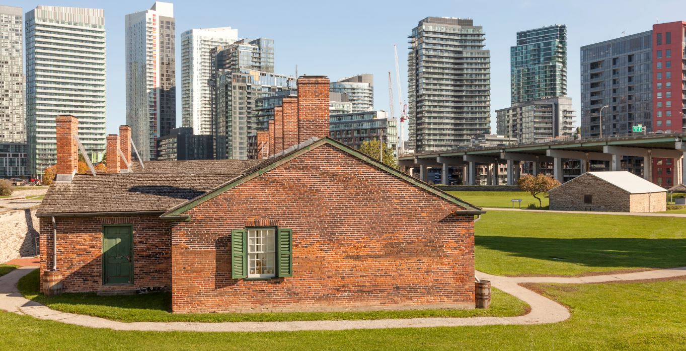
Fort York, a historical sight nestled in the bustling City of Toronto, stands as a testament to our nation's resilient past. Best known for the 1813 Battle of York during the War of 1812 when 2,700 American soldiers captured and occupied the Fort for six days. The Fort served as the harbour's primary defense from the 1790s through the 1880s and today, with the help of survey plans, this historical site is a living homage to our past, symbolizing the identity of our nation.
Survey plans are vital in the preservation process for landmarks such as Fort York, providing essential land details for accurate boundary representation and conservation efforts. Without the information provided by survey plans, the preservation process would lack insight to crucial elements of the land, such as, area, fabric, use, as well as original structures and roads. Additionally, the visual representation offered by survey plans is invaluable for restoration and educational purposes.
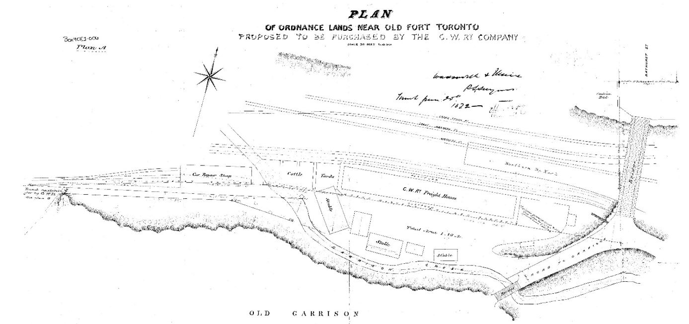
Image courtesy Krcmar Surveyors Ltd - Year:1872
Figure 1. In this survey which dates back to 1872, we can observe a small portion of the Great Western Railway located north of Fort York. The survey depicts various structures such as stables, a freight house, a car repair shop, and cattle yards, all of which provide insight into the infrastructure of that era. Additionally, we see a bridge crossing over the train tracks to Bathurst Street bearing a striking resemblance to the historic Sir Isaac Brock bridge that stands today. These details help us visualize the past and illustrate the evolution of the land and its use.
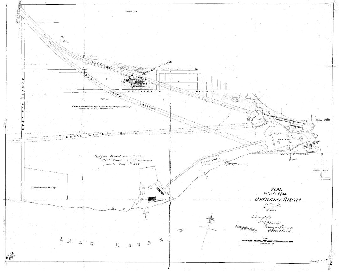
Image courtesy Krcmar Surveyors Ltd - Year:1877
Figure 2. In this survey, the scene shifts to 1877 revealing a more expansive look of the area that includes Fort York, New Garrison, and the surrounding lands. Positioned just above Fort York is the area depicted in Figure 1. This plan highlights multiple railways leading into the city past Fort York, a layout that remains consistent with the modern landscape. This continuity helps us appreciate the historical context of the area and understand how it has shaped the present-day infrastructure, such as the GO Transit Lines, which now occupy the same routes.
Exploring further, the area depicted in this survey plan has undergone significant development (and redevelopment) since 1877. Today, it is home to numerous popular attractions, most notably, the Exhibition Grounds, BMO Field, Budweiser Stage, as well as trendy neighbourhoods like King West and Liberty Village. The absence of Coronation Park (1937) and the Ontario Place grounds (1971) in this survey emphasize the significant transformation this land has undergone in its physical appearance and its primary use since the 1800’s.
Defining the Land
In 1973, the Toronto City Council recognized the significance of Fort York by naming it in the inaugural City of Toronto Inventory of Heritage Properties. This was a crucial first step in acknowledging the fort's historical importance and ensuring its preservation for future generations. Further designation in 1985 recognized the entire Fort York area as a heritage conservation district, solidifying Fort York's status as a cultural landmark in the growing City of Toronto.
In 2004, the city expanded the district boundaries to encompass more of the surrounding landscape, extending to the area to include the Strachan Avenue Burial Grounds and the Queens York Rangers Museum (the Fort York Armoury). Victoria Memorial Park, a nearby burial place for those affiliated with Fort York, was also recognized by the Historic Sites and Monuments Board of Canada as a National Historic Site.
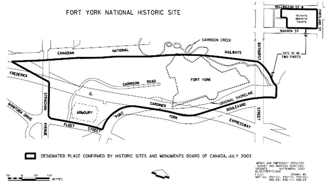
Fort York National Historic Site, September 2003
Toronto Works & Emergency Services. Drawn: WS.
Image courtesy Works & Emergency Services/Survey and Mapping Services, City of Toronto
Map No. 49G-12, 49G-13, 49G-22, 49G-23, 50G-11. GOG-21
Figure 3. The protected area illustrated within the thick black line extends to the Canadian National Railway lines to the north, Bathurst Street to the east, Strachan Avenue to the west, and Fort York Boulevard/Fleet Street to the south.
The inclusion of sites beyond the fortress walls provides a thorough view of the neighbourhood's historical significance and contributes not only to its preservation, but also, it’s development.
Fort York Today:
While Fort York preserves its historical core, the area around the fort has seen significant development in recent years, with modern condominiums and office buildings rising alongside the historic site. Guided by survey plans, developers have transformed this area into a vibrant community boasting art galleries, restaurants, shopping, and an outdoor recreation area known as the Bentway, seamlessly blending The Fort with modern civilization while maintaining its historic significance.


Protect Your Boundaries Inc. is a licensed member of the Association of Ontario Land Surveyors, and is entitled to provide cadastral surveying services to the public of the Province of Ontario in accordance with the provisions of the Surveyors Act R.S.O. 1990, Chapter S29.