Beneath Our Feet: How Old Surveys Reveal Toronto’s Hidden Waterways

When travelling along the paved roads and concrete paths of Toronto, many people are unaware that they are closer to a river than they think. Beneath the ground and carefully designed parks of Toronto flow a network of buried rivers, creeks, and brooks that once carved deep ravines through the city's landscape. Today, many of these waterways are hidden, but historical surveys help to keep their memory alive.
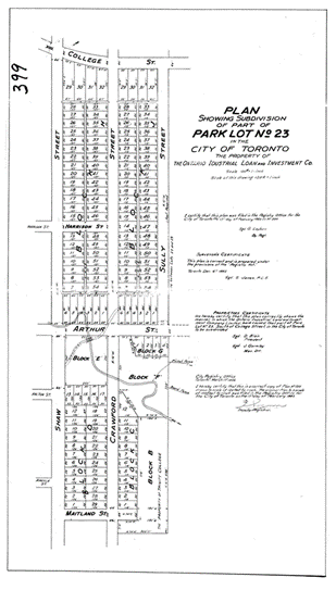
Garrison Creek and the City It ShapedLong before tall buildings, streetcars, bike lanes, and concrete paths, Toronto was shaped by its natural waterways. Among the most famous of these waterways was Garrison Creek, which flowed from the St. Clair Ravine down through what is now Christie Pits, Trinity Bellwoods, and Fort York, where it opened into Lake Ontario. Looking through the survey records of Toronto, from the 1800s, you can see many traces of winding waterways coursing their way through the city. In fact, many of Toronto’s quirks, such as strange street angles or oddly shaped lots, are directly inherited from the topography of these creeks. Clues in the StreetsA good good example of this occurs in and around the Little Italy neighbourhood, more specifically, on Crawford Street and Montrose Avenue, between College and Harbord Streets. College and Montrose do not follow a typical grid pattern, as landowners in the early 1800s laid out their own roads and paths according to natural features of the land. As the city grew and formalized the street grid, some of the older paths were grandfathered in, which is the likely cause for the perplexing layout around these roads. It is fascinating to imagine what these roads would have looked like before the city built up around them, and to recognize that these roads were laid out well before any official urban planning came into place. They were purely designed by the land itself, rather than a grand design. |
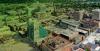
This historical survey captures Garrison Creek as it winds beneath the Crawford Street Bridge, a buried yet structurally intact piece of Toronto’s lost landscape. Once an open waterway shaping the neighbourhood’s topography, the creek was gradually buried in the early 20th century. |
|
|
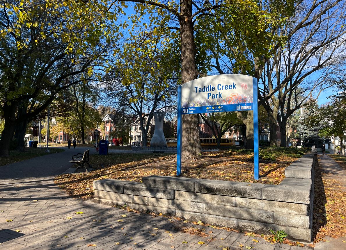
Why Did We Bury Our Rivers?As Toronto grew in the late 19th century, open rivers became less picturesque and more problematic. Garrison Creek and others like Taddle Creek and Castle Frank Brook became polluted with industrial waste and sewage. City planners also saw the rivers as obstacles to expansion, so one by one, the rivers were converted into underground sewers and erased from the city grid. Historic Surveys may show a creek surrounded by large plots of land, but by 1910, that same area may show straight-lined, grid-like subdivisions. Traces of the past:Though now out of sight, Toronto’s lost rivers still have a presence within the communities they helped to form: Trinity Bellwoods Park: Once a deep ravine carved by Garrison Creek, the Crawford Street Bridge once spanned the creek. In 1966, rather than demolishing the bridge, the city decided to fill in the creek and bury the bridge where it stood. A small plaque marking the area where the bridge is buried commemorates the bridge's history and location. Christie Pits Park: This area was once a sand pit where the Garrison Creek flowed through. It was transformed into a public space in the early 1900s. To this day, the area is still prone to water accumulation. Philosopher’s Walk: This is a short pedestrian path on the University of Toronto grounds that follows part of the route where Taddle Creek once freely flowed. |
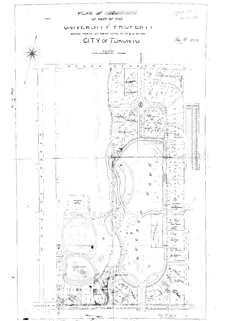
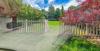
This historical survey reveals the original path of Taddle Creek as it once flowed through the grounds of the University of Toronto, long before it was buried beneath Philosopher’s Walk and adjacent academic buildings. |
| These and many more hints of the old rivers can be found around the city if you know what to look for. You can often identify paths of the old rivers by slight changes in elevation, unusually lush vegetation, or sometimes, flooded basements in adjacent homes, the unfortunate result of ancient waterways asserting themselves after a heavy rain. | 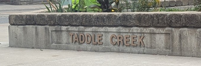 |
Reading the City Through Surveys
These maps offer more than nostalgia; they reveal the hidden stories of past land use, the environmental impact of urbanization, and the ambitions of a rapidly growing city.
If you were to lay a historical survey map over today’s city grid, you would realize just how much of Toronto has been shaped by its natural features. Despite the efforts of city planners and land developers, these features never fully disappear; they linger in the contours of the land, the quirks of the streetscapes, and in the historic surveys that remind us that these rivers were once a part of everyday life in Toronto.
References:
1. "Philosopher’s Walk." Toronto Journey 416, https://www.torontojourney416.com/philosophers-walk/. Accessed 4 Sept. 2025
2. "Crawford Street Bridge." Read the Plaque, https://readtheplaque.com/plaque/crawford-street-bridge#gsc.tab=0. Accessed 4 Sept. 2025.
3. "Christie Pits Park." City of Toronto, https://www.toronto.ca/explore-enjoy/parks-recreation/places-spaces/parks-and-recreation-facilities/location/?id=196&title=Christie-Pits-Park. Accessed 4 Sept. 2025.
4. Khan, Derek Flack. "A Brief History of Garrison Creek, Lost but Not Forgotten." blogTO, 14 Mar. 2012, https://www.blogto.com/city/2012/03/a_brief_history_of_garrison_creek_lost_but_not_forgotten/. Accessed 4 Sept. 2025.
5. Khan, Derek Flack. "A Brief History of Taddle Creek, Toronto's Lost Treasure." blogTO, 15 Mar. 2012, https://www.blogto.com/city/2012/03/a_brief_history_of_taddle_creek_torontos_lost_treasure/. Accessed 4 Sept. 2025.


Protect Your Boundaries Inc. is a licensed member of the Association of Ontario Land Surveyors, and is entitled to provide cadastral surveying services to the public of the Province of Ontario in accordance with the provisions of the Surveyors Act R.S.O. 1990, Chapter S29.