49% of GTA properties have ‘boundary time bombs’

Approximately 49 per cent of residential properties in the Greater Toronto Area have property boundary discrepancies that could lead to disputes between neighbours, a study by PYB shows.
A random sample of 415 land survey plans from the City of Toronto and the regional municipalities of Durham, Halton, Peel and York revealed that 205, or 49 per cent, of the properties have a misplaced fence or other encroaching structure or occupation issue with the potential to create conflict between neighbours.
Halton Region and the City of Toronto had the greatest percentage of potential boundary disputes, at 63 and 59 per cent respectively. Only 47 of the 415 plans (11 per cent) had no identified boundary issues, while 16 per cent had a potential title problem.
Ideally, property owners enjoy their properties within clearly defined boundaries, and land rights are mutually understood and respected. However, the exact position of the boundary is often assumed or unknown when fences, sheds and other structures are built. This creates ‘boundary time bombs’ that can be triggered when new owners acquire a survey plan, when an addition is undertaken or when someone simply measures the width of their property. These situations cause stressful animosity between neighbours and may lead to expensive court action.
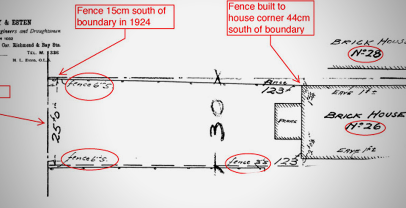
One such dispute arose in 2004 over a strip of land about a foot wide between two houses on Johnston Avenue in North Toronto, a case that came before the courts as Cantera v. Eller. The incorrectly sited fence at the heart of the issue was first revealed by a survey done in 1952 – a half-century earlier. The case finally reached its conclusion at the Ontario Court of Appeal in 2008, with total legal costs estimated at close to $100,000.
Many property line disputes can be avoided or mitigated by examining the property survey plan, especially before buying a property or building a new structure. A survey plan will show the exact location of the property lines, including the location of any iron bars or other survey monuments that mark boundary corners on the ground.
PYB makes it easier and more cost-effective than ever before for homeowners to find existing survey plans – the street address is all that’s needed to search our database of plans for more than one million GTA residential properties.
A new survey plan is most often a homeowner’s best resource; however, previous survey plans of a property can provide a great deal of valuable information about the true boundaries and history of development on the site. For example, older survey plans may reveal when a fence or addition was built, which may affect current development plans or help to resolve present-day property boundary concerns.
The usefulness of an existing plan depends on the situation, the type of plan available, the age of the plan, and how much the property has changed over time, which is best determined in consultation with a professional Ontario Land Surveyor or a real estate lawyer.
A home is the biggest investment most people make, and it’s essential for homeowners to understand the true nature and extent of the land they own in order to fully enjoy their property, maximize its value and peacefully coexist with their neighbours.


Protect Your Boundaries Inc. is a licensed member of the Association of Ontario Land Surveyors, and is entitled to provide cadastral surveying services to the public of the Province of Ontario in accordance with the provisions of the Surveyors Act R.S.O. 1990, Chapter S29.