The Foundation of Flavour: St. Lawrence Market’s Historic Role in Toronto

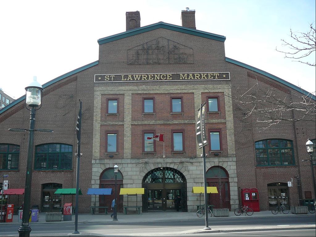
When you walk through the St. Lawrence Market today, it’s easy to get swept up in the scents of fresh produce, the sound of merchants calling out specials, and the feeling that you are a part of something that has been happening here for centuries- because you are. The market has been a vital part of Toronto’s story since 1803, and through every phase it has been mapped, measured, and immortalized in the pages of land surveys.
A marketplace is BornIt all started when Lieutenant Governor Peter Hunter assigned the area as a public market in 1803, offering local farmers and vendors a designated space to sell their goods. The first buildings were erected by 1814, and by 1831, the North Market received its first permanent brick structure. This was seen as an investment in infrastructure that signaled the markets growing importance. Survey plans from this time show a city well on the verge of expansion with street changes, lots being divided, and permanent city spaces being established. These plans, were meticulously hand-drawn, and give us insight not only into where buildings stood, but into how Toronto was choosing to define itself. |
 |
|
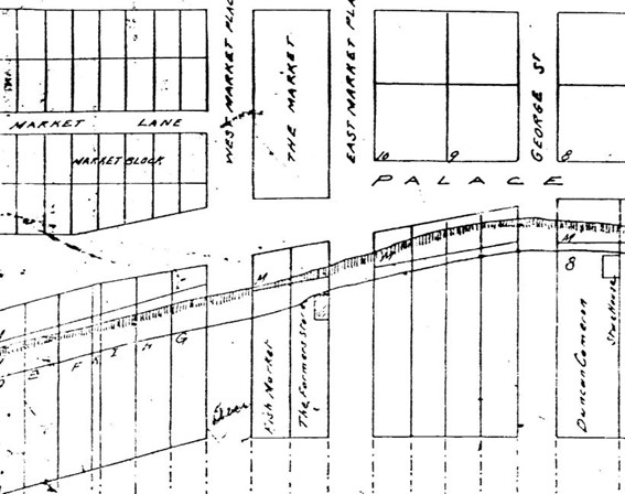
This partial clipping from an undated survey plan shows the layout of Toronto’s historic market district, including the North Market, the Fish Market, and Farmers’ Store House. This map was likely created in the mid-1830s, shortly after the Town of York was incorporated as the City of Toronto in 1834. We can estimate the timeframe based on the use of "City of Toronto" in the title and the appearance of infrastructure associated with early city planning along the waterfront. |
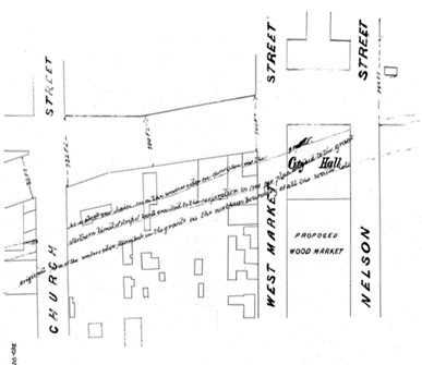
A hall of Civic PrideBetween 1845 and 1899, the South Market was more than just a place to shop — it was Toronto’s City Hall. A detailed, undated survey in our archives clearly marks the “City Hall” site east of what was then West Market Street and west of Nelson Street (now Jarvis Street). This snapshot in time shows the layout of streets and the proposed south market structure, providing a visual record of Toronto’s past political heart. The building’s architecture itself told a story: yellow bricks, produced locally from the Don Valley clay, gave the building its distinctive tone. These bricks which are rare today weren’t just aesthetic choices. They were symbols of local industry and craftsmanship. When the city outgrew the space and moved its administrative functions elsewhere in 1899, those yellow bricks weren’t discarded. They were instead incorporated into the design of the new South Market, which opened in 1902. The bricks remain visible today along the front of the building, offering visitors a physical connection to Toronto’s early days. |
 |
A Legacy of Transformation
In 1904, just two years after the South Market opened, the North Market was rebuilt to accommodate the city’s expanding population and needs. Then, in 2015, it was demolished once again to make way for a modern, multi-use facility that would include a farmers’ market, antique market, and even municipal courts, a subtle nod to its earlier role as City Hall. The new building is set to open in May 2025.
These waves of transformation have been thoroughly documented in land surveys. From property boundaries to building outlines, survey plans are often the only surviving documentation of what once stood and what was planned. They offer continuity in a city that is constantly changing.
Surveying Toronto’s Soul
At Protect Your Boundaries, we use historic surveys like those from the St. Lawrence Market area to help property owners, developers, and historians piece together the city’s layered story. These plans aren’t just documents, they’re tools of memory, architecture, and law.
 |
They help ensure that redevelopment respects heritage, that boundaries are clearly understood, and that the story of Toronto’s growth is never lost.
|
References
1. St. Lawrence Market. History. Retrieved from: https://www.stlawrencemarket.com/history
2. City of Toronto. St. Lawrence Market – Booking City Facilities. Retrieved from: https://www.toronto.ca/services-payments/venues-facilities-bookings/booking-city-facilities/st-lawrence-market/
3. Filey, M. (2017, May 11). Once Upon a City: St. Lawrence Market at Centre of Toronto’s History Since 1831. The Toronto Star. Retrieved from: https://www.thestar.com/news/gta/once-upon-a-city-st-lawrence-market-at-centre-of-toronto-s-history-since-1831/article_ebe14e3c-a700-589a-a84a-5a6a1edf74d8.html
4. City of Toronto. (2023). St. Lawrence Market Strategic Plan (Updated Photos Version). [PDF]. Retrieved from: https://www.toronto.ca/wp-content/uploads/2023/05/9803-St.-Lawrence-MarketStrategic-Plan-Updated-Photos-Version-3-compre...-FINAL-AODA.pdf
5. Harris, S. (2009). St. Lawrence Market, Toronto. [Photograph]. Flickr. Retrieved from: https://www.flickr.com/photos/stevenharris/3446341486/in/photostream/


Protect Your Boundaries Inc. is a licensed member of the Association of Ontario Land Surveyors, and is entitled to provide cadastral surveying services to the public of the Province of Ontario in accordance with the provisions of the Surveyors Act R.S.O. 1990, Chapter S29.